File:Bronglais General Hospital (Aberystwyth, Wales) department map and part of department guide.jpg


Original file (4,032 × 3,024 pixels, file size: 2.54 MB, MIME type: image/jpeg)
Summary
Description
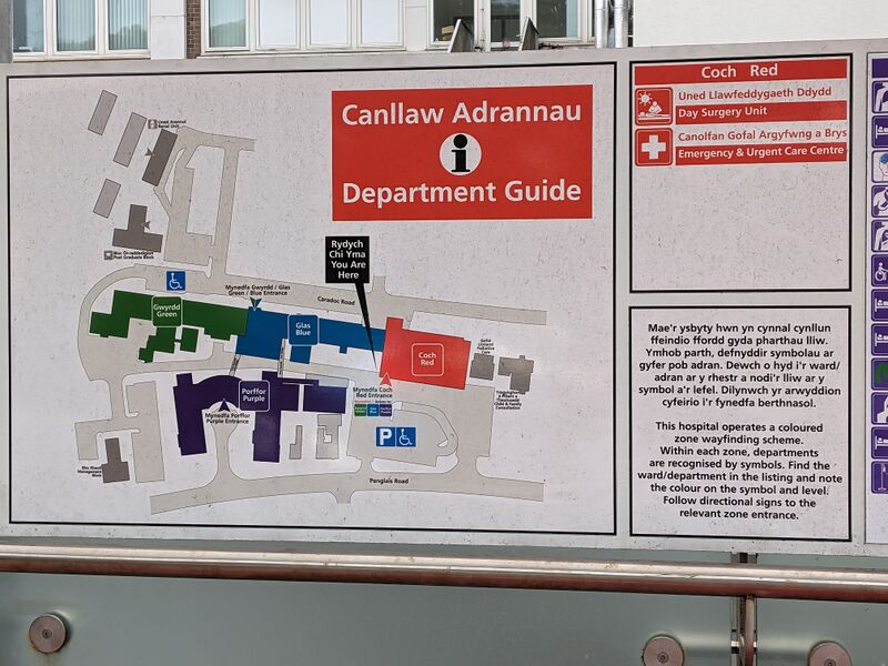
Photograph of the bilingual (Welsh/English) map and part of the department guide/index for Bronglais General Hospital, Aberystwyth.
Map title: Canllaw Adrannau / Department Guide.
Map shows four departments (Gwyrdd/Green, Glas/Blue, Coch/Red, Porffor/Purple), entrances, parking and disabled parking, plus surrounding roads (Caradoc Road and Penglais Road) and some outlines of surrounding buildings.
First guide/index section:
Coch / Red:
Uned Llawfeddygaeth Ddydd / Day Surgery Unit
Canolfan Gofal Argyfwng a Brys / Emergency & Urgent Care Centre
Introductory text:
Welsh: Mae'r ysbyty hwn yn cynnal cynllun ffeindio ffordd gyda pharthau lliw. Ymhob parth, defnyddir symbolau ar gyfer pob adran. Dewch o hyd i'r ward/adran ar y rhestr a nodi'r lliw ar y symbol a'r lefel. Dilynwch yr arwyddion cyfeirio i'r fynedfa berthnasol.
English: This hospital operates a coloured zone wayfinding scheme. Within each zone, departments are recognised by symbols. Find the ward/department in the listing and note the colour on the symbol and level. Follow directional signs to the relevant zone/entrance.
More info
- Date: 2023-04-17 13:29:13
- Source: Photo taken by Cassolotl
Photograph taken outdoors in public of publicly owned building map in the UK (Wales), which is also outdoors; see COM:FOP.
Entire map and department guide index: File:Bronglais General Hospital (Aberystwyth, Wales) department map and department guide.jpg
_department_map_and_department_guide.jpg)
_department_map_and_department_guide.jpg)
File history
Click on a date/time to view the file as it appeared at that time.
| Date/Time | Thumbnail | Dimensions | User | Comment | |
|---|---|---|---|---|---|
| current | 18:02, 29 April 2023 | | 4,032 × 3,024 (2.54 MB) | Cassolotl (talk | contribs) |
You cannot overwrite this file.
File usage
The following page uses this file:
_department_map_and_part_of_department_guide.jpg&oldid=22)